Greetings from the Gulf of Mexico!
We have now completed half of our sections in Mexican waters, and we are currently finishing up the first of two new lines in the Mexican EEZ: the Merida Line and the Cabo Catoche Line (Figure 1). We hope to capture a region of upwelling of acidified waters in the Cabo Catoche Line and see how conditions change as waters move along the Yucatan platform and into the Bay of Campeche.
Speaking of the Merida Line, this set of stations will bring us fairly close to the Alacranes (Scorpion) Reef, a Mexican National Park and UNESCO Biosphere Reserve. Alacranes Reef is the largest coral structure in the Southern Gulf of Mexico at 17 miles long and about 13 miles wide. It is the only reef located right in the middle of the GOM open ocean and along the route from the Caribbean to the ports of the Gulf of Mexico, so many a ship has been wrecked in its treacherously shallow waters (hence the name Spanish sailors gave it, alacranes, after the deadly animals). The science crew agrees that perhaps a scientific visit to this amazing reef should be explored for GOMECC-5.

Figure 1: GOMECC-4 station plan showing the two new lines in Mexico and location of Alacranes Reef (left) and a blowup showing the reef in more detail (right). Images from Google Earth Pro.
In science-related updates, we are now starting to look a bit closer at our data set as scientists copy their preliminary data onto our ship’s shared drive. The University of South Florida team in charge of pH and carbonate measurements just shared a picture with us (Figure 2) with the samples collected on station 98 (the offshore station on the Merida Line). pH on the cruise is measured spectrophotometrically via addition of a purified dye called m-cresol purple, which changes color based on the pH of the water. Our scientists on board measure the absorbance (the amount of light “absorbed” by the sample) at different light wavelengths, and from that they can calculate the pH with a high degree of accuracy and precision. In Figure 2 you can visually appreciate how the pH varies at different depths in the water column.
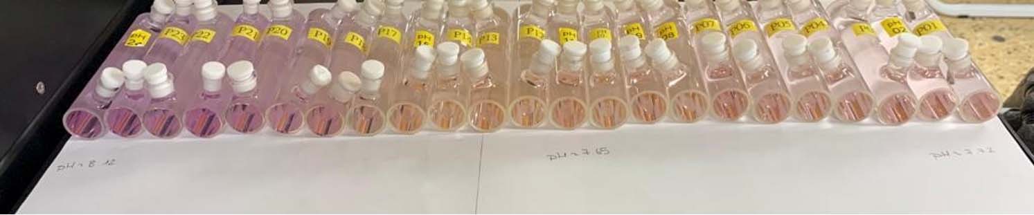 Figure 2: pH samples collected at station 98 (23.183N, 90.642W) from surface (left) to bottom (right). Photo credit: Macarena Martín Mayor (University of South Florida).
As we expected, we have noticed a significant increase in surface carbon concentrations as we moved into the warmer Bay of Campeche (Figure 3). Except for the low values that were measured in the Mississippi region, surface carbon concentrations in the GOM are well above 400 ppm in general. In the west Yucatan shelf values are upwards of 450 ppm. Please note that these are preliminary data that still need to be calibrated and quality controlled, but the variability and ballpark numbers should stay fairly consistent.
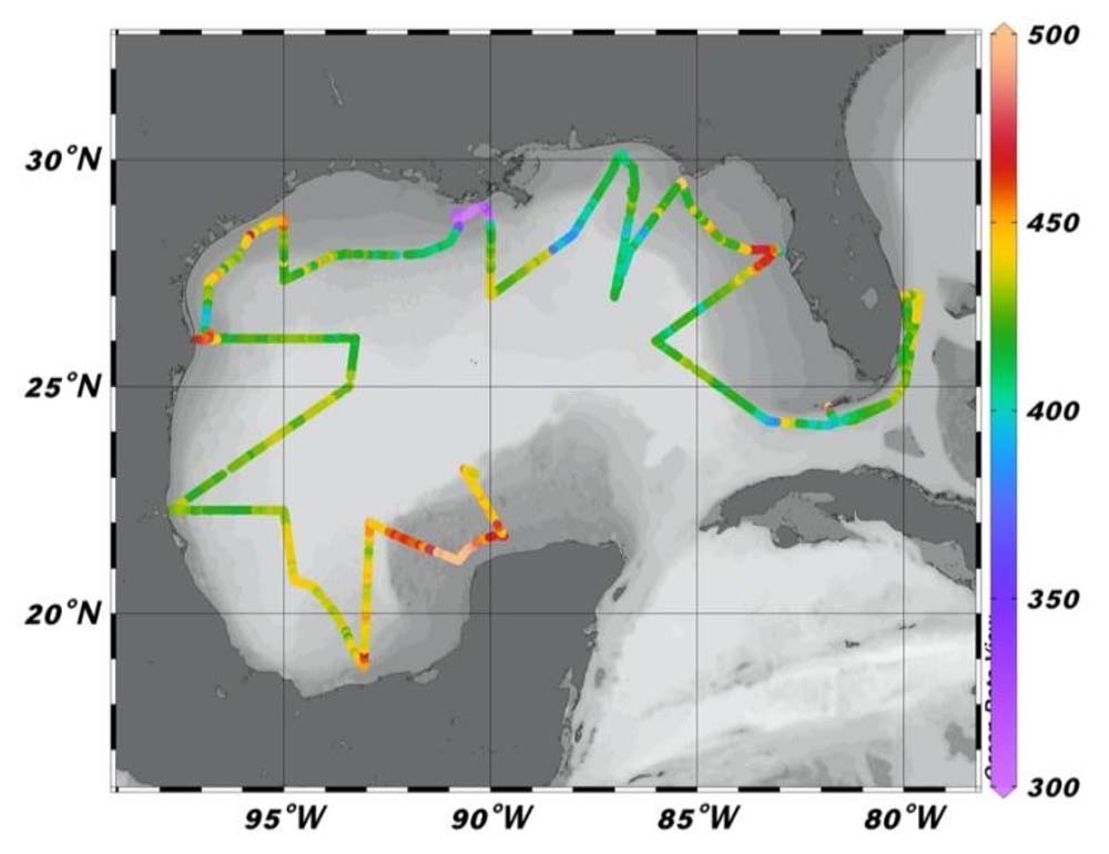
Figure 3. Preliminary mole fraction of carbon dioxide (xCO2, ppm) along the GOMECC-4 cruise track.
After yet another last-minute change of port, we have started to work on the logistics for the new port that we will be arriving to, St. Petersburg, FL. Lots of flights, hotels, and shipments to change, but we will get it done.
Onwards!
Leticia Barbero and Andy Stefanick, chief scientists GOMECC-4.

